THE PACIFIC NORTH
Pacific Costa Rica covers a vast sweep of territory along the wide side of the country, from Nicaragua down to the Panamanian border. Overlooking a complicated, varied terrain are the volcanoes and mountain peaks of the Guanacaste, Tilarán, and Talamanca mountain ranges, which largely block the rains that blow across Costa Rica from the Caribbean. Winds from the Pacific blow rain clouds ashore from May through October, while the rest of the year is dry.
But there are exceptions to this general picture. The Guanacaste lowlands of the northeast, hemmed in by coastal mountains, are subject to periodic droughts. In the south, on the other hand, near Golfito, the coastal mountains act as a watershed, and it rains throughout the year. In general, rainfall, humidity and discomfort increase toward the south. The daytime temperature throughout the area is generally in the nineties Fahrenheit (32 to 37 Centigrade).
Puntarenas is a one mile-long sandspit (which is what its name means), sticking out into the Gulf of Nicoya, a narrow, muddy estuary on one side, clear water on the other. Opened to shipping in 1814, the port was for many years Costa Rica’s only outlet to world commerce. The coffee crop moved down to the coast from the highlands on oxcarts with a legendary breed of driver, rough and ready, but scrupulously honest.
The location of Puntarenas would appear strategic for the visitor. Ferries provide the easiest access to some of the nicer beaches on the Nicoya peninsula. Cruises touch the many islands in the Gulf of Nicoya. Puntarenas is the nearest Pacific point to San José.
Unfortunately, though, some of the city is a dump. I don’t mean only that the beach is contaminated for its whole great length along the south side of town The central part of the city is composed of dismal, rotting and rusting, ramshackle structures, cheap flophouses, and bar after bar oozing drunks. A stench often permeates the humid, dense air.
Beyond the commercial center, the sights are more pleasant. There are some nice residences and hotels near the western tip of town and back toward the mainland, and a substantial yacht club. The headquarters of the port, at the main pier, are in a lovely old building. On Calle 7, there is a marvelous tan, crazy-stone church, looking quite English. Eating in the open-air diners along the beach and mixing with the crowds that come down for the day from San José can be pleasant. But you didn’t come all the way from home to linger here. Costa Rica has much nicer seaside places to offer.
Southwest of Cañas, near the mouth of the Tempisque River, is Palo Verde National Park, a reserve of seasonally dry tropical forest of the type which once covered much of this area. Birds flock to Palo Verde, and so do birders: the leafless state of the trees during the dry season mates it easy for the latter to view the former. At least 300 species have been recorded at Palo Verde. There are hiking trails and observation points.
Less developed for visitors is the adjacent wetland Lomas Barbudal Biological Reserve, a refuge for migrating waterfowl, including herons egrets, ducks and grebes. The station for the reserve is reached by taking an unpaved road from the kilometer 221 marker on the Pan American Highway, negotiable in a sedan in the dry season. Six kilometers out, the terrain drops off sharply, from bare flatlands with scattered trees to a river bottom that remains moist throughout the year, alive with bird songs and dense with trees and bushes. If you arrive by car, continue to the second parking area, adjacent to the station, if road conditions look promising. Here bird lists and T-shirts are on sale, and there are exhibits of butterflies and other fauna. There are trails from this point, and a picnic area nearby.
At the mouth of the Tempisque River is the Rafael Lucas Rodríguez Caballero Wildlife Refuge (Refugio de Vida Silvestre), which encompasses passes a variety of habitats ranging from dry forest to marsh to lagoons to pasture and evergreen groves, where peccaries, deer, white-faced monkeys, waterfowl and crocodiles can be observed, among others. The Rodríguez Caballero Refuge may be reached by raft and motorboat from the La Pacífica ranch and hotel along the Pan American Highway.
Located 36 kilometers north of Liberia, Santa Rosa National Park was established in 1971 as a historical monument. The natural treasures of the park, which were originally included only incidentally, are now the main attraction for the foreign visitor.
The Santa Rosa hacienda was the scene of one of Costa Rica’s most glorious military episodes - an episode that lasted the approximately fourteen minutes it took for a Costa Rican force to defeat the invading army of William Walker on March 20, 1856. Walker’s army -and much of the opposing Costa Rican army as well- was finished off not long afterward in a cholera epidemic. The original great house of the Santa Rosa hacienda still stands as a monument to the victory.
Among the many natural features of the park are an extensive protected area of deciduous dry tropical forest; and Nancite beach, where hundreds of thousands of Pacific Ridley turtles nest from August until December every year.
Partly because of its historical importance, the park is quite well run, and is one of the most visited in the national park system. Best time to visit Santa Rosa is in the dry season, when thirsty animals congregate around the permanent water holes and streams making for easy viewing. During the rainy season, when few visitors appear, markers along the nature trail mar be down.
Facilities at or near the park center include a historical museum in the old great house of the hacienda, seven kilometers from the Pan American Highway, and a nature trail nearby. The campsite, about a kilometer away, back toward the park entry, then down a side road, near the administration building, is basic, with showers and latrines, as well as many picnic tables. There’s a small fee to camp, in addition to the admission fee to the park.
The casona, or great house of the Santa Rosa hacienda, is a large, whitewashed building with an aged tile roof and wooden verandas. Part of the casona might date from the colonial period, though the age of the building is indeterminate. Houses of this sort were continually repaired, remodeled and expanded during their useful lives. The stone corrals around the house are almost certainly a few hundred years old, and were in use until the hacienda was nationalized. Great wooden mortars and pestles lie in the shade of the eaves. In the clearing in front of the casona is a huge guanacaste tree, witness to past battles.
Nancite Beach is one of two known nesting areas in Central America for the Pacific Ridley Sea Turtle. During the rainy season, the turtles crawl up onto the beach, first by the dozens, then the hundreds, then thousands, to shove each other aside like so many commuters fighting for space, dig nests, and lay eggs before departing for the open sea. Green and leatherback turtles nest at the beach as well, but in smaller numbers than the Ridleys. With humans and other predators scooping up eggs when park employees aren’t looking, and vultures and frigate birds diving down for bits of hatchlings, less than one percent of the eggs make it to the young turtles. Crabs and sharks lie in wait to further deplete their numbers.
Access to Nancite is controlled, in order to protect the turtle eggs. Inquire at park headquarters before heading for the beach, by trail or in a four-wheel drive vehicle.
Naranjo, a larger beach than Nancite is an excellent locale for bird watching. You can camp here along the shifting estuary. The Mirador Valle de Naranjo trail affords a view of Naranjo Beach, as well as of the Peña Bruja outcrop.
Cuajiniquil ("kwa-hih-nih-KIHL") Canyon, at the northern edge of the park, contains a series of waterfalls, as well as numerous palms and ferns in its moist environment. Platanar Lake, covering a hectare, is four kilometers north of the great house and administrative area, and attracts varied waterfowl as well as mammals during the dry season.
North of the main section of Santa Rosa Park is the Murciélago Annex, a rugged, seaside strip of scrub forest and rocky outcrops where jaguars and mountain lions roam. Notable in this section of the park is Poza El General, a year-round waterhole, which can be reached by trail.
The Murciélago section was expropriated by the Costa Rican government from former Nicaraguan president Anastasio Somoza. Access is via the Pan American Highway to the turnoff for Cuajiniquil village, 30 kilometers north of the junction for the main section of Santa Rosa Park. The entrance to the park annex is eight kilometers past Cuajiniquil.
There are also several isolated beaches near Cuajiniquil, both within and without the park. Playa Blanca is especially pretty. You can sometimes hire boats to poke around the inlets or to take you to the Murciélago ("bat") Islands, about 25 minutes out to sea.
Junquillal Bay Recreation Area (Area Recreativa Bahía Junquillal) including turtle nesting sites, dry forest and mangroves, is currently being developed for visitors, with campsites and trails.
About 14 kilometers northeast of Nicoya, off the road that leads to the Tempisque River and the Pan American Highway, is Barra Honda National Park, with its extensive limestone caverns, and peaks offering long distance views out over the Gulf of Nicoya.
Barra Honda mountain, once thought to be a volcano, rises 300 meters above the surrounding plain, and is pocked by holes where the roofs of underlying caves have collapsed. The caves were formed - and are still being formed - by the rapid erosion and chemical decomposition of layers of limestone sediment that once lay on the bed of a prehistoric sea. A geological fault line runs roughly along the nearby Tempisque River; the former seabed was steadily lifted as the Nicoya Peninsula slid alongside the mainland.
There are more than two dozen caves in Barra Honda, some of them still hardly explored.
Facilities in Barra Honda Park include trails, latrines, drinking water, and a campsite. The bluffs are high, and will require quite a lot of exertion to ascend. Park headquarters are in the town of Barra Honda, four kilometers west of the highway from Nicoya to the Tempisque River. It’s another six kilometers meters to the center of the park.
Playas del Coco (El Coco Beach) is a dramatic setting on a large horseshoe bay with great rocks offshore, sailboats gliding around, and dozens of fishing boats tied up or on their way in to or out from shore. But this is one of the Pacific points most easily reached from San José, and it shows. The little town and the central part of the beach are dirty, though there’s less litter the farther you walk from the center.
Three kilometers south of El Coco, Ocotal is reached by an unpaved road, rutted and difficult to negotiate in the rainy season. But there are rewards, if you’re interested in a secluded hotel, deep-sea fishing, or diving.
Four kilometers onward from the turn for Villas Pacífica is Flamingo Beach, a stunning horseshoe of white sand in the web of a hand-shaped promontory, bordered by cliffs and a large hill.
What distinguishes Flamingo is what man has added to nature: a marina which, though small, is the most complete in the region. For all the money that has been poured into the attractive facilities at Flamingo, there’s no town, and little shade. If you’re not into fishing, sunbathing and real-estate pitches, and don’t have a car to circulate to other locales, Flamingo can get old rather quickly. Flamingo has the air of a town looking for the next rich sucker to come along.
Tamarindo is a wide, mostly empty beach curving around a miles-long bay, with rocks and little sandy islands offshore. Pelicans float overhead and dive into the waters, skiffs bob up and down in the gentle surf. The setting is nearly perfect. And yet, many who know the Nicoya beaches say that Tamarindo is spoiled. Which is a measure of what some of the other beaches are like.
The village is fairly peaceful and low-key. The tamarinds that give the beach its name are the trees with the dangling seed pods and brush-like leaves. Birding is excellent in the nearby mangroves and tidal pools.
Tamarindo National Wildlife Refuge, south of the village of Tamarindo, is a turtle nesting area that also includes a variety of mangrove types. Birding trips through the waterways of the reserve and turtle-watching trips in the nesting season (November through April) are available from local operators. Typical species are egrets, frigatebirds, pelicans, gulls, spoonbills, and Muscovy ducks.
Opposite Puntarenas are the dramatic bays and inlets and sandy and rocky beaches of the very end of the Nicoya Peninsula.
Despite the proximity of San José in a straight line, limited ferry service, poor public transportation, unpaved roads and the fact that this is a dead end have, until recently, made the area relatively little-traveled. Of course, these are ideal conditions for those who wish to make discoveries away from the crowd at their own pace.
The two gateways to this area, from Puntarenas, are the ferry ports of Playa Naranjo and Paquera.
THE PACIFIC SOUTH
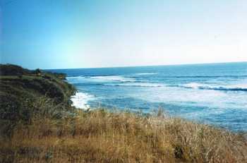
The southern Pacific beaches of Costa Rica are every bit as inviting and pleasing to the eye as those along the Nicoya Peninsula, though they differ in character. Most are more open, sweeping, and exposed, with fewer bordering outcrops of rocks. The farther south you go, the more humid and rainy is the climate, and the more lush and exuberant the vegetation that runs up to the sand. The mugginess is always relieved and attenuated, however, by breezes blowing off the water.
There is one fact about the southern beaches that is often not mentioned in polite company: they are dangerous for swimming. Large volumes of water flow toward shore across a deceptively smooth, broad front of waves, then recede in fast-flowing, unpredictable streams. If you are not a good swimmer, stay close to shore.
Beach hotels are concentrated at Jacó and at Manuel Antonio (near Quepos), but there are numerous little-frequented beaches as well where cabinas and similar basic accommodations are available. You can poke round and explore for some of these paradisaical hideaways if you decide to rent a car in San José.
Jacó ("ha-KO") has what other beach places in Costa Rica are missing: streets, and life. It is a pleasant community, where you can stroll and look in stores, shop for groceries, choose from a selection of restaurants and snack bars and buy a souvenir at some place other than the captive boutique of your hotel. Vacation houses are scattered on coconut-palm-shaded lots, surrounded by wild grass and carefully manicured gardens. Accommodations range from basic to expensive, and there are definitely places in between.
Jacó is the nearest of the beach resorts to San José (if you don’t count Puntarenas), three hours away by public bus, less by car, or a half-hour hop by chartered plane. The beach at Jacó is typical of this section of coast— wide, long, curving to promontories, littered with driftwood, palm-fringed in parts, vegetation creeping over some small dunes. There is also a certain accumulation of trash -diapers, bottles, juice cartons- in the most frequented sections, but the beach is large enough that most of it is inoffensive. Surfers have mace Jacó their home away from home.
And there are natural attractions, as well. Sea turtles lay their eggs most nights from July to December at Playa Hermosa, three kilometers to the south.
Corcovado National Park, in the southern part of the Osa Peninsula, includes vast stretches of the only virgin lowland rain forest in Central America. Among the natural treasures of Corcovado are trees of 500 species (including one kapok, or silk-cotton, that is said to be the largest tree in Costa Rica); numerous endangered mammals, among them cougars, jaguars, ocelots, margays, jaguarundis and brocket deer; eagles and macaws, assorted monkeys; snakes; tapirs; and peccaries, which may be the most destructive and dangerous species in the park.
Vegetation zones range from mountain rain forest down to beach, and fresh-water and mangrove swamps. At La Llorona, a river empties in a waterfall directly into the ocean.
You don’t just drop into Corcovado. With its remote location, Corcovado attracts mainly scientific researchers, and visitors on all-inclusive packages with boats, buses and oxcarts organized beforehand. There are extensive trails along the beach and in the forested interior, however, as well as campsites. You can do Corcovado on your own if you’re prepared with camping equipment, rain protection, high boots, snakebite kit, food, water containers and purification means, and repellent against the sandflies that infest the beaches. For walking along the beaches and up the beds of rivers, old sneakers, rafting sandals or surf shoes will come in handy.
Check with the park service in San José before any visit to Corcovado, or at least with the park of office in Puerto Jiménez (tel. 778-5036). Allow for contretemps - chartered planes that don’t show up to airlift you out, never-ending downpours, bogged-down buses, etc.
Admission to the park costs about $6. Meals are currently available at ranger stations at $4 for breakfast, $6 for lunch or dinner; though there is no guarantee that vittles will be available if you just drop in. Advise park headquarters in Puerto Jiménez of your scheduled whereabouts, when possible.
There are no sheltered bays along this stretch of coast, and the breakers are often over ten feet high. Sharks frequent the waters off the entire face of the peninsula (in case you doubt it, look at the skulls that decorate lodges and the general store in Carate). Swimming should be ruled out, except for a wade near shore. Sharks also swim into the rivers of Corcovado when the water is over a meter deep.
Ridges of high jungle run parallel to the beach of pebbles and black sand, split from each other by meandering rivers. Birding is excellent from any vantage point along the beach, (viewing along interior trails in the park maybe limited by the close foliage and lack of windows). The Madrigal River, about two kilometers from La Leona station, is marked by a boulder beach, where broad waves crash against the gentle curve of coast.
Carate, about a kilometer past the eastern edge of Corcovado Park, is a pulpería (general store), a dirt landing strip, and a rusting sluice that remains from the days when gold panning was legal. This is the end of the dirt road around the edge of Osa from Puerto Jiménez, and some camper vehicles make it this far and use the beach as a base for exploring the park.
The lush, rolling landscape south of Puerto Jiménez is cattle country, sprinkled with surviving and second-growth forest, ponds where ducks and geese putter about, and plots of fast-growing pulp trees where cleared and burned-off forest produced luxuriant pasture and abundant crops only until the ashes and humus were exhausted and the hard clay below had nothing more to yield. The bumpy road south fords assorted rivers and streams; bridges are being installed, in some cases by the U.S. Army Corps of Engineers, and National Guard units. The farms and pastures soon diminish in numbers and extent, for there are only limited accessible markets.
Think of Zancudo as a tropic isle. A beach village south of Golfito, Zancudo can be reached overland if you have a sturdy vehicle and no schedule, or if the bus is running on the day you go. But most of the connections are by water.
"Zancudo" (san-KU-do) is the Spanish word for a particularly vexatious mosquito; though you will usually not be bothered if there is any kind of breeze. The settlement sprawls along five kilometers or so of beach, and at most of the lodging places, you’ll see sand, breakers, mangrove, coconut palms, and maybe another building down the way a bit, if at all. Surfers have come here for years, and now there is just enough in the way of amenities to make Zancudo the right place for anyone who requires a beach without Big Tourism.